Beyond the Tap, Part 4: Floyd's Water Budget Study
The preliminary study emphasizes the “fragility of the system during drought" due to Floyd’s geographic location and its dependence on “water recharge,” which is the process of water infiltrating the ground and refilling fractures via precipitation, runoff, and the like.

Last March, a team from Virginia Tech presented a Preliminary Groundwater Assessment for Floyd County to the county’s Board of Supervisors with the goal of helping officials and residents better understand the local water budget, which examines how much water enters the county’s underground system and how much is removed.
Data used throughout the research includes specific numbers for well depth and yield by location, details about Floyd’s subwatersheds, and a soil analysis. It also accounts for the drought periods from 1988 and from 1998-2002. The full report, including maps and other graphics, can be found here. (Note the study largely gathered and presented preliminary data and did not detail future planning.)

The VT study indicated that Floyd County uses 1.17 million gallons of water per day (about 100,000 gallons of which are delivered through the Floyd-Floyd County Public Service Authority system) and addressed the sources of water throughout Floyd County: primarily wells that have successfully hit fractures where water is stored in underground rocks. There are about 3,660 wells within the county.
Kalinda Bechtold, who served on the PSA Board during her time representing Indian Valley on the Board of Supervisors, explained, “There is a misconception that [our] water table — the depth you hit water when drilling — is the same as an aquifer — basically an underground lake or river.” She added that “we do not have a large river to draw water from, there is no surface storage like a lake, and no aquifer storage to speak of.”
Bechtold said that while the PSA’s customer base has grown and its infrastructure has continued to age, its wells are also operating at a diminished capacity. She said the wells are producing 77% of what they did when they were first drilled.

Hardwood, LVP, Carpet, Tile & Stone. We've got it all! Floyd Floor Co. brings quality and craftsmanship to every home for every budget. From design selection to expert installation, we handle everything. Call or visit our showroom to see what's new and get your free estimate today! 540-302-2858
Mike Maslaney, who is a member of the PSA’s Board of Directors, explained that officials typically do a “draw-down test” every 10 years on each well to record its production capacity. He said he hopes to complete the process this spring or summer to get updated numbers.
The 2025 Water Budget Study notes that there are no identified aquifers throughout the Blue Ridge physiographic region, and groundwater resides in fractured rock up to about 1,000 feet below the surface. “Fractures are not typically continuous even across short distances… Productive wells intercept multiple fractures at various depths,” the study said.
The study also emphasizes the “fragility of the system during drought" due to Floyd’s geographic location and its dependence on “water recharge,” which is the process of water infiltrating the ground and refilling fractures via precipitation, runoff, and the like. Land cover and characteristics of the soil also impact recharge.

We offer locally sourced, insect and rot resistant hemlock, and lots of other species for just about any project.
We also can provide firewood, kindling, mulch, sawdust, and shavings.
Inside we produce paneling and flooring in various, often rustic local woods.
Come by or call Stacy
276-692-8754
About 62% of Floyd County is covered by forest, according to a 2021 chart included in the study. Furthermore, 64.5% of the county is covered in soil from “Hydrologic Group B,” which is “deep, well-drained soil with a moderately fine to moderately coarse texture and a moderate rate of infiltration and runoff.” In these areas, the maximum recharge rate per day is 0.6 inches.
About 16% of the county is covered in soil categorized as Hydrologic Group C. This is soil “with a layer that impedes the downward movement of water or fine textured soils and a slow rate of infiltration.” The maximum recharge rate per day in these areas is 0.12 inches.
One tool discussed in the study to help predict the timing and distribution of potential recharge is the Soil-Water-Balance (SWB) Model, a program by the U.S. Geological Survey that can estimate recharge per subwatershed. The Widgeon Creek–Smith River Subwatershed, which is 1,092 acres on the east side of the county, contributes more than 15 inches per year to water recharge. The highest recharge rates are relatively concentrated at either end of the county, and they collect more than 20 inches of recharge each year.

602 East Main Street
Floyd Virginia
540-745-8686
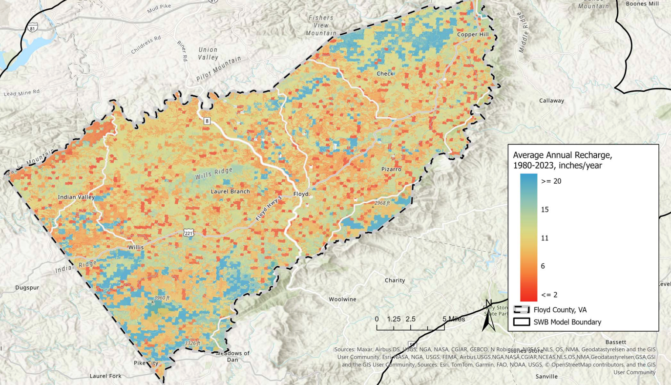
The entirety of the PSA system sits on the border of the Dodd Creek–West Fork Little River and the Pine Creek–Little River subwatersheds, which both contribute about 10 inches of recharge to the fractured rock system per year, according to the VT study.
County Administrator Kim Chiddo said that as a result of the preliminary study, the county has invested in stream and rain gauges. In 2025, she said, the Virginia Department of Emergency Management installed three real-time rain gauges at various locations and one flood gauge on Dodd Creek. The Board of Supervisors partnered with the Virginia Department of Environmental Quality (VDEQ) to install seven additional stream gauges, and the process was completed last month, she added.
"Together the real-time rain gauges and stream flow gages will provide robust data to strengthen the Floyd County groundwater model," Chiddo said. "Residents and businesses in the county can do their part to encourage groundwater recharge by slowing rain run-off on their property rather than trying to pipe it away quickly."
Types of development, including buildings, roads, and parking lots, can be an obstacle for recharge, especially if they aren’t constructed with the local water table in mind. Bechtold said that in her opinion that aspect of the study should be pursued further. “If the current wells are producing less water, what impact does altering the land with roads, houses, and such, have on the wells?” she asked.